
 Continue with onX Maps
 Continue with Facebook


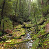
 Particularly Special Place


 Intermediate

 Intermediate
Land Manager: California State Parks - Santa Cruz District
 Castle Rock Loop
3.6 mi 5.8 km • 658' Up 200.45 m Up • 692' Down 210.96 m Down
 Monte S…, CA
 Lane Camp Loop
12.7 mi 20.5 km • 1,582' Up 482.06 m Up • 1,582' Down 482.09 m Down
Boulder…, CA
Berry Creek Falls Loop
9.7 mi 15.6 km • 1,844' Up 562.19 m Up • 1,835' Down 559.42 m Down
Boulder…, CA
State Park Trifecta
28.0 mi 45.0 km • 4,083' Up 1244.45 m Up • 4,122' Down 1256.51 m Down
Saratoga, CA
 Waterfall Loop Nature Trail
1.0 mi 1.7 km • 320' Up 97.46 m Up • 318' Down 96.97 m Down
Day Valley, CA
Wildcat Loop
5.0 mi 8.1 km • 564' Up 171.99 m Up • 564' Down 171.84 m Down
Loyola, CA


0 Comments