Dogs Unknown

Features
Views

This is a high elevation area so access is normally possible after the Fourth of July to late September due to snow. This singletrack trail is non-motorized.
Description
This trail descends from the Goldstone Jeep Road into upper Bloody Dick Creek. It then climbs up the divide between upper Bloody Dick Creek and Park Creek before descending the full length of Park Creek.
It is a lightly traveled trail, and the trail markers are hard to see across the upper meadows. Runners should be adept at route finding between the trail blazes or use the
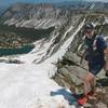
Trail Run Project mobile app to help find the way. The trail goes through a lodgepole pine forest so expect some downfall. The trail is just on the east side of the Continental Divide and the views in the upper section are terrific.
You can make a side excursion to Swift Lake, just west of this trail on another poorly marked trail. The Park Creek Trail is in a remote area and is usually accessed by the road between Reservoir Lake and the Upper Bighole River.
Beware of the locally famous mosquitoes.
Contacts
Shared By:
Wayne Hecker

 Continue with onX Maps
 Continue with Facebook


 Particularly Special Place


 Difficult


0 Comments