Dogs Unknown

Features
Views
Description
Phillip's can make for a very nice, long climb at roughly 9 miles long. This trail is usually done as a shuttle with a car parked down in Wilson. Other options are to climb the trail then descend Snotel and Phillips Canyon back to the car. If you choose this option, you can run into Wilson, then up the path to the Phillips Canyon trailhead parking lots for a loop.
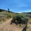
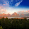
From the Arrow Trail junction the trail climbs about 1 mile to the top of the ridge. The climb is moderate through dense aspen forest and the open meadow. From the top of the ridge you can see down into the Valley and town of Jackson and the Teton Peaks. The aptly named trail now follows along the ridge, which has a mixture of embedded rock and roots throughout the section.
After this scenic ridge run, you'll wind back through dense forest. Switchbacks are abundant here as you make your way down. Eventually, Phillip's Ridge meets up with Phillips Canyon at the bottom with a short connector trail run out to the pavement on Fish Creek Rd.
Contacts
Shared By:
todd saulters

 Continue with onX Maps
 Continue with Facebook


 Particularly Special Place


 Intermediate


0 Comments