
 Continue with onX Maps
 Continue with Facebook


 Particularly Special Place


 Intermediate

 Intermediate
Land Manager: NPS - Redwood
 Trillium Falls Loop Trail
2.7 mi 4.3 km • 510' Up 155.43 m Up • 509' Down 155.26 m Down
Redwoods Splendor Loop
16.9 mi 27.3 km • 3,718' Up 1133.29 m Up • 3,708' Down 1130.34 m Down
Westhav…, CA
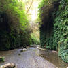
James Irvine to Fern Canyon
11.9 mi 19.1 km • 1,610' Up 490.67 m Up • 1,610' Down 490.63 m Down
Crescen…, CA
Friendship Ridge Loop Hike
8.0 mi 12.9 km • 1,168' Up 355.87 m Up • 1,167' Down 355.68 m Down
 Westhav…, CA
 Lyons Ranch Trail
3.6 mi 5.8 km • 463' Up 140.98 m Up • 463' Down 141.06 m Down
Westhav…, CA
 Damnation Creek Trail
3.7 mi 6.0 km • 1,215' Up 370.28 m Up • 1,200' Down 365.65 m Down
Bertsch…, CA


0 Comments