Dogs Unknown

Features
Views
Description
Access to trailhead: From Okutama Station, take the Nishi Tokyo bus bound for the Nippara Shonyudo 日原鍾乳洞 (25 mins, 450 yen). Get off at the Naka Nippara 中日原 bus stop. There is a restroom and a large map of the area at the stop. The actual trailhead is up the road a hundred yards or so to the left.
You first descend into a ravine, crossing a bridge and then make your way up Inamuraiwa Rock 稲村岩. This is then followed by a long ascent along the Inamuraiwa Ridge 稲村岩尾根. After about 2.5-3 hours from the trailhead, you'll reach the summit of Mt. Takanosu 鷹ノ巣山 (1,736 m).
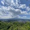
Stop and enjoy the view! If you are doing this on a nice weekend, you'll probably not be alone, but the climb is difficult enough that you'll be one of only two dozen or so, which is basically as close to alone as you might get in Japan!
Shared By:
Dylan Pradas

 Continue with onX Maps
 Continue with Facebook


 Particularly Special Place


 Intermediate/Difficult


0 Comments