Dogs No Dogs

Features
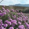
Cave · Views · Wildflowers

The Smugglers Pass Trailhead and Ron Coleman Trail are currently closed while the park finishes rerouting the lower portion of the trail, and for rehabilitation.
Official hours for the Franklin Mountains State Park headquarters are 8 am to 5 pm. Both ends are accessible outside of these hours no gates and pay stations are located at both trailheads. Fees are $5 per adult and are free for children 12 and under. The busiest seasons are spring through fall.
Overview
Rocky, rugged, and battered by the sun and wind, the Franklin Mountains are home to over a hundred miles of scenic but unforgiving desert trails. The Ron Coleman Trail is widely considered the centerpiece of the Franklins, stretching between two canyons along the ridgeline. Steep and difficult, with two sections requiring bouldering, it is not a trail for the faint of heart. However, those who finish Ron Coleman are rewarded with views of three states in two countries and the distinction of completing the most challenging trail in El Paso.
Need to Know
Like other trails in the Franklins, there is no shade or water available along Ron Coleman. Plan to avoid the hotter parts of the day. Also, check the wind when reviewing the forecast; gusts over 20 mph can make the ridge and climbing segments uncomfortable. 30-35 mph should be the no-go point for most runners.
The chain-assisted sections require about thirty total feet of climbing up a near-vertical rock face. Be sure to assess your fitness before proceeding. If you are unable to do a pull-up, you're probably not in good enough shape to complete the full trail.
While there is no "official" direction to take the Coleman Trail, most users making the full journey do so from the south to north. The primary reason is to take on the chain assists as a climb instead of a descent; going down is more difficult than going up. The blue dot markings also are oriented more towards the south, making pathfinding easier.
Runner Notes
Despite its difficulty, the Ron Coleman Trail is one of the most popular routes in Franklin Mountains State Park. Most people only make it as far as the caves on the southern end or
Mammoth Rock on the north side. Expect to share the trail with others, many who may be out of their element and are unfamiliar with trail etiquette. Be polite.
Ron Coleman is rugged and rocky, similar to other difficult trails in the area. Trail shoes are strongly recommended. Bring plenty of water, and allow for extra time â€' even the most experienced runner will find themselves moving slowly on this difficult trail.
Description
The southern end of the Coleman Trail is found at the back of McKelligon Canyon. Initially a wide doubletrack, it quickly narrows to single and makes a slow circle to the left of the canyon. Visitors familiar with other area trails will find Coleman's composition about the same: frequently rocky, with hardpacked dirt underneath.
Soon, the first of two caves found along the route comes into view. The portion between here and the ridgeline becomes fairly steep, and at the quarter mile point, the trail starts to split into several parallel segments. All are within a few feet of each other, and they eventually end at the cave, so pick whichever one makes the climb easier. Covered in graffiti by local idiots, the cave marks the turning point for most casual trail users.
Look to the right of the cave opening for a narrow track making a steep ascent. A red arrow painted onto the rocks can help. This section may require some minor scrambling, but some poured concrete steps assist in the climb. After reaching the top of the cave, the trail continues to the left. Another cave is visible to the right and can be reached by going off trail a bit. The remainder of the climb to the ridge is similar to the path before the first cave, with a few more splits and occasional loose rock. The path can be faint at points, so look for areas without vegetation indicating prior foot traffic.
An impressive view of both sides of El Paso awaits at the ridgeline. Turn right and continue along the top of the mountain range. For the next two miles, a series of blue dots spray painted onto rocks help mark the trail. Experienced runners won't have much trouble locating the rugged path, but the dots can help guide through ambiguous portions.
As it transits the ridge, Coleman occasionally forks and rejoins. The left segments follow the higher line and tend to be more scenic and challenging, whereas the right side drops down a few feet, blocking the winds that whip up from the west side. At the three quarter mile point, the trail stays on the leeward side, and spends the next half mile in a relatively peaceful climb. Coleman shifts back to the west side of the ridge at the mile and a quarter point. Avoid two false paths branching to the right. Keep an eye out for the blue dots.
The trail then comes to its most challenging segment. First up is a precipitous cliffside section be careful, as a fall would be dangerous followed by the first chain assisted climb. This ascent is short and easy, but the next one, found just ahead, is significantly more difficult. Check for good handholds and move slowly, climbing about twenty feet up the jagged rock face. The reward at the top is
The Window, a hole formed in the mountain through which an impressive view of the east side can be seen.
Two more chain climbs follow, and a lack of good footholds can deter some runners here. Power through to the top and continue on the last climbing segment of the trail, which passes through a mountaintop bowl thick with plantlife. Coleman flattens out just west of the transmitters on South Franklin Peak; a barely visible path leads to the perimeter fence.
Coleman is indistinct through this plateau, passing through numerous creosote bushes. Again, look for the dots. Continue down the other side and curve right around a runoff area. The trail now begins a rugged descent down a washout, directly towards
Mammoth Rock. Some scrambling may be required. At the base of Mammoth, the dots end and the trail turns north for a half mile along the jagged, rocky ridgeline.
At the two and three quarter mile point, Coleman descends down the west wall of Fusselman Canyon in a series of thirteen switchbacks. False trails lead off from the south end of many of these; stay on track. The hairpins, covered in talus, make for a grueling climb in reverse.
At the three mile point, the trail reaches the canyon bottom. Coleman ends on a long, bumpy straightaway descent to the parking area.
Flora & Fauna
While not as lush as other area trails, just about every variety of plant life in the West Texas desert can be seen on Ron Coleman. Creosote bushes and cacti are the most common sights, with ocotillos, lechugillas, and sotols all making appearances. A few barrel cacti can be seen on the northern section of the trail. Desert plants bloom in waves from spring to fall, so at any given time during the warmer months, there will be something flowering.
As with the plants, there tends to be fewer animals visiting the rough, wind-swept ridges of Ron Coleman. Watch for small birds and reptiles, with the occasional golden hawk circling overhead. Roadrunners can be seen in the lower sections.
History & Background
The Coleman Trail is named for Ronald D'Emory Coleman, a prominent Texas congressman who played a significant role in protecting the land which would eventually become Franklin Mountains State Park. Residents felt that the Park's centerpiece trail was a worthy tribute to Coleman's work, which created the largest urban state park in the United States.
The north side of the trail ends at Smuggler's Pass. Once a route for cattle rustlers to move between the mountains, it is now the high point of Transmountain Drive, a four lane highway connecting El Paso's two sides. The nearby Fusselman Canyon, through which the Coleman Trail descends during its last half mile, was named for Charles H. Fusselman, a Texas Ranger killed in pursuit of bandits in these mountains.
Contacts
Shared By:
Brendan Ross
with improvements
by Mark Wancho

 Continue with onX Maps
 Continue with Facebook


 Particularly Special Place


 Difficult

 Tour de Lost Dog

 Canutillo, TX
 Franklin Mountains Trail Run 50K
 Lower Sunset Alternate Loop


0 Comments