Dogs No Dogs

Features
Commonly Backpacked · Lake · River/Creek · Swimming · Views · Wildflowers · Wildlife

East of Kearsarge Pass in the John Muir Wilderness, dogs are allowed and no permits are required for day hikes. However, permits are required for overnight stays, trailhead quotas apply, and no campfires are allowed. West of Kearsarge Pass, in Kings Canyon National Park, no dogs are allowed. Wilderness permits are required. You can reserve a permit online, but you must go to the ranger station during business hours to pick up the permit. One-fourth of the quota is available for walk-ups.
Description
This is a strenuous 2600 foot climb over an 11,845 foot pass, but because the trailhead is at 9200 feet, it is much easier than the nearby alternatives: Taboose, Sawmill, Baxter, and Shepard passes, all of which start much lower. The trail is very popular. Many use it for day runs to the east-side lakes or even to the top of Kearsarge Pass. Others use it to access the short trail to the spectacular Kearsarge Lakes or to the beautiful Charlotte Lake, a mile past the end of the trail. Still others use it to access a segment of the JMT or as a resupply route for longer JMT or PCT routes.
Note: the wilderness rules change when you cross Kearsarge Pass and enter Kings Canyon National Park (See below.)
The road from US 395 in Independence to the trailhead in Onion Valley is steep, but paved. There is a lot of parking near the trailhead, but even on a weekday, many cars were parked along the road up to a quarter mile below the trailhead, and there was additional parking extending for another quarter mile.
The first 800 feet of climbing is in semi-desert type vegetation, but there are two long cascades dropping into Onion Valley and views of rugged cliffs in the surrounding ridges. At 10,000 feet, the trail passes Little Pothole Lake, the first of five lakes before the pass. When the trail passes close to the creek just below Flower Lake, there is a signed branch trail to Matlock Lake. This creek is the last water before Kearsarge Pass. From Flower Lake to Kearsarge Pass, the trail is a smooth, steady grade, without the rocky steps found on many other trails.
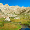
Especially in the morning, Kearsarge Pass has spectacular views to the west of Kearsarge Pinnacles, Kearsarge and Bullfrog Lakes, and the high granite peaks of the King-Kern Divide. On a clear day (somewhat rare), there are sweeping views back over Owens Valley.
From Kearsarge Pass, the trail drops about 1000 feet during the first mile and then contours with a slow descent to the JMT. Until near the end, it stays high above the valley with constant sweeping views.
About 0.5 miles below the pass, there is a branch trail to Kearsarge and Bullfrog Lakes. Kearsarge Lakes are a prime destination in themselves. Bullfrog Lake is beautiful, but no camping is allowed near the lake. The Kearsarge Pass Trail reaches the JMT just before that trail makes its big descent down to Vidette Meadow. Charlotte Lake is only about a mile beyond the end of the Kearsarge Pass Trail.
Contacts
Shared By:
Lee Watts

 Continue with onX Maps
 Continue with Facebook


 Particularly Special Place


 Difficult

 4.7 (18)


0 Comments