
 Continue with onX Maps
 Continue with Facebook


 Particularly Special Place


 Intermediate

 Intermediate
Land Manager: City of Boulder Open Space and Mountain Parks
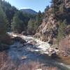
 Walker Ranch, Ethel Harrold, and Canyon Falls
3.5 mi 5.7 km • 583' Up 177.57 m Up • 583' Down 177.57 m Down
Coal Creek, CO
 Flagstaff Summit Loop
2.4 mi 3.9 km • 346' Up 105.4 m Up • 337' Down 102.81 m Down
 Boulder, CO
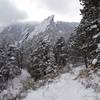
 Royal Arch Out and Back
3.4 mi 5.5 km • 1,252' Up 381.69 m Up • 1,251' Down 381.29 m Down
Boulder, CO
Anne U. White Trail
3.3 mi 5.3 km • 444' Up 135.23 m Up • 444' Down 135.29 m Down
Boulder, CO
Marshall Mesa Valley Loop
2.8 mi 4.5 km • 187' Up 57.1 m Up • 186' Down 56.56 m Down
Marshall Mesa to Spring Brook Loop
11.1 mi 17.9 km • 889' Up 271.11 m Up • 889' Down 271.02 m Down
Superior, CO


0 Comments