
 Continue with onX Maps
 Continue with Facebook


 Particularly Special Place


 Intermediate/Difficult
Intermediate/Difficult
Intermediate/Difficult
 Intermediate/Difficult
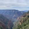
Land Manager: National Park Service - Grand Canyon National Park
 Rim-to-Rim-to-Rim (R2R2R)
47.5 mi 76.5 km • 10,919' Up 3328.07 m Up • 10,919' Down 3328.18 m Down
 Grand C…, AZ
 Rim Trail
13.1 mi 21.0 km • 469' Up 142.87 m Up • 990' Down 301.78 m Down
 Grand C…, AZ
 Transept
2.1 mi 3.3 km • 110' Up 33.45 m Up • 265' Down 80.68 m Down
Grand C…, AZ
 Uncle Jim Complete Loop
4.8 mi 7.8 km • 494' Up 150.7 m Up • 495' Down 150.91 m Down
Cape Final Trail
4.3 mi 6.9 km • 425' Up 129.56 m Up • 425' Down 129.46 m Down
Grand C…, AZ
Flagstaff to Grand Canyon Stagecoach Line 100 Mile
99.6 mi 160.3 km • 5,801' Up 1768.26 m Up • 6,645' Down 2025.38 m Down
Flagstaff, AZ


0 Comments