
 Continue with onX Maps
 Continue with Facebook


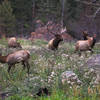
 Particularly Special Place


 Difficult
Difficult
Difficult
 Difficult
Land Manager: National Park Service - Rocky Mountain National Park
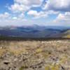
 Mount Chiquita
5.2 mi 8.4 km • 1,934' Up 589.57 m Up • 1,934' Down 589.59 m Down
 Estes Park, CO
 Mirror Lake Out and Back
13.4 mi 21.5 km • 2,078' Up 633.3 m Up • 2,076' Down 632.82 m Down
Deer Mountain Loop
10.5 mi 16.9 km • 1,698' Up 517.54 m Up • 1,698' Down 517.52 m Down
 Estes Park, CO
 Cub Lake Loop
6.1 mi 9.9 km • 629' Up 191.66 m Up • 626' Down 190.66 m Down
Estes Park, CO
Bear Lake TH to Fern Lake TH
8.5 mi 13.6 km • 1,180' Up 359.71 m Up • 2,524' Down 769.27 m Down
Estes Park, CO
Crags Campground to American Lakes
6.5 mi 10.4 km • 1,348' Up 410.76 m Up • 1,347' Down 410.53 m Down


0 Comments