Dogs Leashed

Features
River/Creek · Views · Wildflowers · Wildlife
Overview
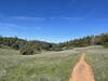
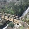
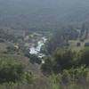
Runners will be treated to several historical sights and spectacular views of the North Fork of the American River along this out-and-back run. With easy to access from Highway 80, this scenic multi-use trail contains a depth of history that can be visited year round. Experience the singletrack toll road that stretches past seasonal waterfalls, an abandoned hard rock mine, with views of the winding American River. Time your spring visit to see a beautiful display of blooming wildflowers and interesting insects from March-May. During the warm months, expect to see gold panners along the banks.
Description
The
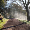
Stevens Trail consists of singletrack trail that is decently groomed with some toe-snagging rocks to watch for. At 0.75 miles, the trail crosses a small creek; follow the trail marker right. At 1 mile, the trail splits; follow the trail and metal post pointing left. This section of trail contains some steeper sections and potential waterfalls. Keep an eye out for a side trail leading directly to the main falls.
At 1.75 miles, will be the abandoned hard rock mine that is it not recommended to explore, as some sections may be unsafe. From here, the trail has steep dropoffs and sun exposure; remember your water as the climb back out is a challenge! Cougars are present in the area along with potentially heavy growth of poison oak, so take caution when on your adventure and enjoy!
Contacts
Shared By:
Kristen Arendt

 Continue with onX Maps
 Continue with Facebook


 Particularly Special Place


 Intermediate/Difficult

 4.5 (33)


0 Comments