
 Continue with onX Maps
 Continue with Facebook


 Particularly Special Place


 Easy/Intermediate


 Easy/Intermediate
Land Manager: USFS - Arapaho & Roosevelt National Forests Office
 Rainbow Lakes
2.5 mi 4.0 km • 293' Up 89.29 m Up • 293' Down 89.22 m Down
Nederland, CO
Sugarloaf Mountain
1.4 mi 2.2 km • 419' Up 127.76 m Up • 419' Down 127.65 m Down
Boulder, CO
Brainard Gateway Figure-8
10.1 mi 16.2 km • 1,290' Up 393.05 m Up • 1,289' Down 393 m Down
East Mag Tour
7.4 mi 11.9 km • 833' Up 254.05 m Up • 856' Down 260.8 m Down
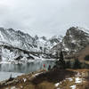
 Isabelle Glacier Out and Back
8.3 mi 13.3 km • 1,549' Up 472.06 m Up • 1,550' Down 472.34 m Down
Nederland, CO
 Mount Audubon and Paiute East
9.7 mi 15.6 km • 3,358' Up 1023.5 m Up • 3,358' Down 1023.41 m Down
Nederland, CO


 Minor Issues


0 Comments