Dogs No Dogs

Features
Views

If it's raining or threatening to rain, you may want to consider another trail due to the fear of flooding in the canyon. The canyon is narrow in several places with some scrambling required over slippery rocks, which could be tricky if it's raining.
Overview
The Desolation Canyon Trail makes its way through a Death Valley canyon before making its way to a ridgeline where sweeping views of Death Valley, the Panamint Mountains, and Artist Drive await you. The trail starts below sea level and follows the canyon floor for a majority of its duration. It gains elevation the entire length of the trail, especially at 2 dry falls just after the 1 mile mark. The first dryfall is 8 feet tall and the second one is 6 feet tall. Both require scrambling or climbing to overcome. On the return trip, you must slide down or climb down, which can be more difficult than climbing up. After these two dry falls are overcome, the trail continues to ascend through the canyon. There are side canyons that are great for exploration, although you have to return to the main trail to get back to your car. At roughly 1.5 mile, two intersections with other canyons might cause confusion, but if you stay to the right, you stay on the trail. After the second right, the trail climbs steeply (20%+ grade for .1 miles) until the trail crests the ridgeline and the sweeping views stretch out before you.
Depending on the time of day, shade may be hard to find, especially if the sun is directly overhead. Make sure to bring plenty of water, sunscreen, and a hat (or head covering of some sort) to help cope with the heat and sun. If you feel you need navigation assistance, free GPX files for GPS or your smartphone can be found at nps.gov/deva/planyourvisit/hiking.htm, and you can also use the
Trail Run Project mobile app.
Need to Know
Drink plenty of water: Drink at least one gallon (4 liters) of water per day to replace loss from sweat, more if you are active. Fluid and electrolyte levels must be balanced, so have salty foods or "sports drinks" too.
Avoid running in the heat: Do not run in the low elevations when temperatures are hot. The mountains are cooler in summer, but can have snow and ice in winter.
Travel prepared to survive: Stay on paved roads in summer. If your car breaks down, stay with it until help comes. Carry extra drinking water in your car in case of emergency.
Watch for signs of trouble: If you feel dizzy, nauseous, or a headache, get out of the sun immediately and drink water or sports drinks. Dampen clothing to lower body temperature. Be alert for symptoms in others.
Description
The Desolation Canyon Trail is located at the end of Desolation Canyon Road, approximately 3.7 miles south of CA Highway 190 on Badwater Road on the left hand side. Take the .5 mile long gravel road to a roundabout where cars can park.
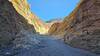
As the trail leaves the parking area, there is a narrow stake in the ground that indicates where the trail leads into a giant gravel wash. One unique feature of this trail is that it actually starts below sea level. Around 50 feet below sea level, to be exact. Working its way through the wash, the mountains and hills on each side of the canyon start to close in on the trail. The trail is well worn into the wash as people have been up into the canyon before you. Various different rock types can be observed in the hills in the area. Working its way into the canyon, there is a hill on the left that can be climbed that looks down on the trail. On either side of the trail, you might encounter a side canyon that you can explore before returning to the trails. There are also gravel washes that show what it looks like when wind and rain move gravel downhill.
At roughly 1 mile, there is an example of what it looks like when a gravel wash works its way onto the trail. A gravel wash has begun to fill the trail with gravel and sand, although its easy to navigate along the side and bypass the obstacle. As the trail continues uphill, an 8 foot dry fall must be overcome to continue on the trail. It does require climbing and scrambling to overcome, but is perfectly doable for those with moderate fitness. On the return trip, it might require sliding down or climbing back down. The trail continues for another .1 miles before another dry fall, roughly 6 feet tall, must be climbed in order to proceed. Again, remember that this must be descended on the return trip, so sliding or climbing back down will be required. Both dry falls have natural ledges and handholds to help traverse them.
The trail continues to ascend through the canyon. Several side canyons are encountered along this portion of the trail that offer the opportunity for exploration. The walls in the canyon in this section are various colors that reflect different minerals found in the rocks. Hematite, Limonite, Chlorite, and Nontronite are just some of the minerals found throughout the canyon. At 1.5 miles, a side canyon goes off to the left while the main trail stays to the right. Shortly after, another canyon intersection is encountered at 1.6 miles and again, the main trail stays to the right. At this point, the trail climbs steeply (over 20% grade for roughly .1 mile) out of the canyon. The gravel is looser through this portion of the trail compared to the canyon floor, but it makes for relatively easy travel uphill, despite the steep grade.
When the trail reaches the ridgeline, expansive views of Artist Drive and Death Valley stretch out before you. You can explore the ridgeline above the canyon, which allows you to look into the canyons that you have been making your way through. On the other side of the ridge, Artist Drive can be seen winding its way through the hills. The
Badwater Basin and salt flats can be seen in the distance to the south. Exploring the ridge line a little further, views of the Furnace Creek area stretch out before you, as well as Death Valley beyond that. The Panamint Range, including Telescope Peak, can be seen across the valley. Once you have taken in all the views, reapplied sunscreen, and grabbed a snack, follow the trail back to your car, possibly exploring side canyons on your way back.
As with all expeditions in Death Valley, make sure you have plenty of water and sunscreen, as well as a hat of some sort, to help protect you from the effects of the sun and heat. In the morning, travel through the canyon is mostly shaded and pleasant, but as the day progresses, the sun finds its way into the narrows and there is no shade when the sun is directly overhead.
Flora & Fauna
There are a few wildflowers along the trail in various parts of the canyon.
Contacts
Shared By:
David Hitchcock

 Continue with onX Maps
 Continue with Facebook


 Particularly Special Place


 Intermediate


 Red Cathedral Out-and-Back
 Badwater, CA
 Zabriskie Point Trail
 Red Cathedral Canyon Crest


 All Clear


0 Comments