
 Continue with onX Maps
 Continue with Facebook


 Particularly Special Place


 Intermediate
Intermediate
Intermediate
 Intermediate
Land Manager: National Park Service - Canyonlands
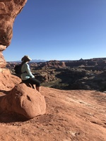
 Grand Viewpoint Overlook Trail
1.8 mi 3.0 km • 154' Up 46.96 m Up • 155' Down 47.12 m Down

 Moab, UT
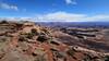
 Long Amasa Loop
15.1 mi 24.3 km • 1,993' Up 607.55 m Up • 1,996' Down 608.33 m Down
Moab, UT
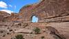
 Amasa Back/Jackson's Loop
6.7 mi 10.8 km • 989' Up 301.46 m Up • 990' Down 301.89 m Down
Moab, UT
Moab Trail Half Marathon
13.7 mi 22.0 km • 1,917' Up 584.15 m Up • 1,919' Down 584.86 m Down
Moab, UT
Moab Retreat: Day 1 Full Pint
13.8 mi 22.3 km • 1,830' Up 557.88 m Up • 1,833' Down 558.64 m Down
Moab, UT
Jeep Arch / Gold Bar Arch Trail
3.8 mi 6.1 km • 918' Up 279.82 m Up • 923' Down 281.31 m Down


 All Clear


0 Comments