
 Continue with onX Maps
 Continue with Facebook


 Particularly Special Place


 Intermediate/Difficult
Intermediate/Difficult
Intermediate/Difficult
 Intermediate/Difficult
Land Manager: NPS - Big South Fork Nat. River and Rec. Area Office
 2019 NB100 Training Camp: Day 1
21.6 mi 34.8 km • 2,391' Up 728.74 m Up • 2,373' Down 723.43 m Down
 Oneida, TN
 Slave Falls Loop Trail
3.2 mi 5.1 km • 378' Up 115.15 m Up • 368' Down 112.19 m Down
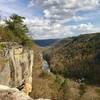
Angel Falls Overlook to Grand Gap Loop
12.0 mi 19.3 km • 1,145' Up 348.93 m Up • 1,143' Down 348.26 m Down
 Oneida, TN
Yamacraw Kids Race
Oneida, TN
Yamacraw Kids Race
1.4 mi 2.2 km • 186' Up 56.68 m Up • 147' Down 44.84 m Down
Stearns, KY
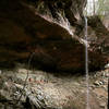
Yahoo Falls Loop
1.1 mi 1.7 km • 176' Up 53.5 m Up • 176' Down 53.51 m Down
Whitley…, KY
 Moonbow 50K
29.0 mi 46.7 km • 2,673' Up 814.72 m Up • 2,674' Down 815.14 m Down
Whitley…, KY


0 Comments