
 Continue with onX Maps
 Continue with Facebook


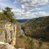
 Particularly Special Place


 Intermediate/Difficult
Intermediate/Difficult
Intermediate/Difficult
 Intermediate/Difficult
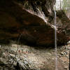
 Honey Creek Loop
4.2 mi 6.7 km • 565' Up 172.29 m Up • 571' Down 174.17 m Down
 Huntsville, TN
 Angel Falls Overlook to Grand Gap Loop
12.0 mi 19.3 km • 1,145' Up 348.93 m Up • 1,143' Down 348.26 m Down
 Oneida, TN
John Muir Trail: Big South Fork NRA
Oneida, TN
John Muir Trail: Big South Fork NRA
49.9 mi 80.3 km • 6,267' Up 1910.14 m Up • 5,972' Down 1820.33 m Down
 Slave Falls Loop Trail
3.2 mi 5.1 km • 378' Up 115.15 m Up • 368' Down 112.19 m Down
No Business 100 Course
102.2 mi 164.5 km • 8,781' Up 2676.57 m Up • 8,784' Down 2677.23 m Down
Jamestown, TN
Yahoo Falls Loop
1.1 mi 1.7 km • 176' Up 53.5 m Up • 176' Down 53.51 m Down
Whitley…, KY


0 Comments