 Race - Jun 29, 2019
Dogs Unknown

Features
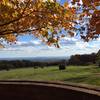
Fall Colors · River/Creek
Overview
This trail offers little in the way of vistas, but more than makes up in challenge. Steep vertical climbs are the least of the challenge as boulders, loose rocks, slick mossy sections, multiple stream crossings, and severely sloped trail push runners beyond the physical and into a mental challenge. Although only 3,500 of elevation gain over the 26 miles, nearly all of which occur in the final 10 miles, and 1,400 in the final 3-mile push up Blue Knob from the valley floor. Look to the
Lost Turkey Trail Ultra for guidance.
Need to Know
The trail can be confusing to follow, especially between miles 5.5 and 8.5. Make sure you have both the
Trail Run Project mobile app and the Pennsylvania data downloaded if you're running with your phone.
Description
From the start, LTT tests your mental and physical states by combining boulder hopping with a slowly steepening climb (500 ft) up Pot Ridge. Unable to find a rhythm, it's best to be patient through these opening miles and not burn your legs. Keep in mind, there is plenty of climbing left to be run. At miles 2.5 and 5.5, you'll cross Pot Ridge Road and Hollow Road, respectively. Between Hollow Road (mile 5.5) and Skyline Drive (mile 8.5) you must be careful to stay on the correct trail, because the LTT is blazed in Red for 90% of the entire trail, but Orange in this section, and possibly mixed with Red. Honestly, it's confusing. Runner Beware!
Once you cross Skyline Drive you'll cross Buffalo Road in the next 1/4 mile. Runners will climb a short hill before descending and running along the precipice of the Allegheny Front. You'll be able to look out over the valley, just slightly, as constant tree cover will prevent a full vista. You'll also be able to see Blue Knob in the distance, giving perspective on where you are, you're going, and how much more climbing you'll need to do, because the next big move is into the valley and the multiple ridges you'll summit. Wrapping up this section, you'll exit the woods and run approximately 1.5 miles along Buffalo Road, a dirt/grass fire road before making a right at King's Fields, which is easy to miss.
As you pass through King's Fields you'll be given you first downhill section of the trail. A continuous 4-mile section weaves its way down the mountainside. A very runnable section of trail. You're almost done when you cross a wooden (a bunch of fallen trees nailed together) bridge over Big Break Hollow and follow the stream to Burnt House Picnic Area (mile 17).
Cross over Burnt House Road and begin the first major climb of the trail. Nearly 20% grade, you'll climb through a valley to the top of Forks Ridge and then along the ridgeline. The trail forks to the right and up a short incline, where at the top a small cairn sits. Shortly after this section you must run for a mile over trail that is severely sloped, affectionately dubbed mountain goat pass by the local running scene. Within this ridge, not exactly sure where, you'll have some climbing to do. It's steep and not insignificant at maybe 300-400 feet. But, make it through all this and you'll then begin your descent to Bob's Creek.
At Bob's creek, you have two options: 1) Cross using the two metal tension ropes which form a sort of bridge, 2) walk across in knee deep water. The water is icy cold, even in summer, offering a nice reprieve in hot conditions, if that helps you decide.
From Bob's Creek runners face a significant climb (the second major climb) to Hog Back Ridge. Again, nearly 20% grades mixed with sloped trail and loose rock make a tough climb even tougher. At the peak you'll come to a "T" in the trail, where you'll make a left, followed shortly after by a right, then taking you back down into another valley.
This valley offers moss-covered boulders, several crossings over the stream. While the profile may suggest a quick descent, you may be slowed by these conditions. Look for the Lost Children's Monument, marking the last 1/4 mile of this section.
At mile 23 make a right on the road, and look for the trail to your left, beginning the 1,400-foot climb to Herman Point in Blue Knob State Park. Consisting of two climbs, the first section is essentially a washout cut into the mountain. A runnable section between climbs passes right by the campground, before the final climb crossing over Pavia Road, up Herman's Stairs, and to Herman Point. \
The final half mile is a quick run through woods along a connector trail to the finish line at Blue Knob Lodge parking lot. This final half mile has two quick rises, which can be almost too much on the legs.
The race put on a grill offering burgers, fried chicken (so good) and tons of fruit and drinks. A MUST DO race pushing runners beyond.
Contacts
Shared By:
Kevin Ketchman

 Continue with onX Maps
 Continue with Facebook


 Particularly Special Place


 Intermediate/Difficult

 Rock 'N The Knob Trail Challenge - Marathon - 2021

 Lake Shore Trail
 Bedford, PA
 Marsh Trail
 Laurel Highland 70.5mi Ultra Run


0 Comments