Dogs Off-leash

Features
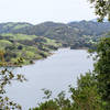
River/Creek · Spring · Wildlife

Open all year, with a park curfew at 10 pm.
Overview
This is a great 7-mile loop with easy access to water. This trail includes big hills, rolling hills, flats and downhills. There are lots of dense redwood forest that make it a great choice for a relatively cool run on a hot day. In the winter, enjoy the lush ferns under the redwood canopy.
Need to Know
This loop is mostly shady. Water can be found at the start at the Richard C. Trudeau Conference Center and where the Graham and West Ridge trails intersect.
Runner Notes
Description
Park at the Trudeau Center parking lot off of Skyline Blvd. Follow the
Dunn Trail, which starts behind the Trudeau Conference Center. You immediately pass Sargent Cypress trees on your left, a California endemic tree with a relatively small distribution.
You then head uphill through the another unique California habitat, Serpentine Prairie. You can stop to read abut this ecosystem on an informational placard. Continue up the
Dunn Trail to the
Graham Trail, and turn left. Run on the
Graham Trail for just over 1 mile; this section is mostly uphill and on a fire road. You'll arrive in an large open area called Redwood Bowl. There is a water fountain here.
Next, take a sharp right onto the
West Ridge Trail. After .1 mile, take the first trail that breaks off on the left. This is the
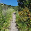
Madrone Trail. Take this singletrack trail .5 miles to the
French Trail. Take a right on
French Trail and run for 2.5 miles. You are traveling along a steep hillside under a redwood canopy on a very unique trail in the East Bay. This trail ends at a junction with the
Orchard Trail.
Take a right and head uphill for .2 miles to West Ridge. Take a right on West Ridge, and continue .3 miles to the
Baccharis Trail. Take a left onto
Baccharis Trail. After .5 miles, this trail will take you back to
Dunn Trail. Bear left onto the
Dunn Trail. After .85 miles running through a beautiful live oak canopy that is the quintessential coastal California habitat, you'll return to the intersection of the Dunn and
Graham Trail. Hang a left here and take the
Dunn Trail back to the parking lot where you started.
Flora & Fauna
In addition to a great forest of coastal redwoods, the park's 1,830 acres also contain other evergreens, chaparral, and grasslands. Wildlife within the park includes rare species such as the golden eagle and Alameda striped racer. Deer, raccoons, rabbits, and squirrels are often seen.
History & Background
The forest's peaceful groves give little evidence of the park's bustling past–in the mid-1800s the area was the scene of extensive logging to supply building materials for the city of San Francisco. The logging era has long since passed, and a stately forest of 150-foot coast redwoods (Sequoia sempervirens) has replaced those that were cut down. There was one particularly giant tree in this forest that was used by 49'ers as a navigational guide through the Golden Gate before it was cut down during the logging era.
Contacts
Shared By:
Michael Beetham

 Continue with onX Maps
 Continue with Facebook


 Particularly Special Place


 Intermediate

 4.5 (36)


1 Comment