Dogs Leashed

Features
River/Creek · Views · Wildflowers · Wildlife
Overview
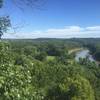
This is a great escape if you are living in St. Louis, or a great stop-off if traveling through St. Louis. The route is rolling, with a pretty high level of solitude for being so close to a large city. There are several overlooks of the Missouri River and the eastern forest is always appreciated by me.
The trail can be (and almost always has parts that are) very muddy.
If looking for a shorter option, or a longer by doubling up a loop, you can also choose to run the
Clark Trail which reduces this loop down to 5.2 miles by cutting through the middle of this loop.
Need to Know
There is plenty of parking, but it can fill up on the weekends. If the parking area is full, you can park just north of the trailhead at another parking area used for the bike trail and run to the trailhead. Fear not, even with the trailhead full, the trail itself still does not attain the sense of being crowded.
Runner Notes
The trail does alternate between one that is smooth and one that is rocky and full of roots, trying to lull one into a sense of complacency before reaching its tentacles up to gab a foot or two.
Description
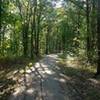
For this trail, there is not much to describe. It is simply a pleasant run through the woods.
From the trailhead, start up the dirt road to the left. Signs will guide you, and you'll soon find yourself on nice, padded, gently-rolling, singletrack. After a couple of miles, the trail begins to climb to the top of the bluff overlooking the river. The views are great. I tis definitely worth heading to the rock ledges for a gander.
The trail will roll along the bluff before dropping down to the right and away from the river about 6 miles in. This is a steep, rocky, and often muddy section.
The last couple of miles spend a lot of time rolling and following a couple of creeks. Simply follow the trail, which will result in one last climb up the side of a hill returning you to the trailhead.
Contacts
Shared By:
Greta Noack

 Continue with onX Maps
 Continue with Facebook


 Particularly Special Place


 Intermediate/Difficult

 4.3 (42)


0 Comments