
 Continue with onX Maps
 Continue with Facebook


 Particularly Special Place


 Easy/Intermediate


 Easy/Intermediate
Land Manager: Cleveland MetroParks
 North Chagrin Mega Loop
8.0 mi 12.8 km • 483' Up 147.26 m Up • 483' Down 147.12 m Down
Mayfield, OH
 Patented EZ 7
7.4 mi 11.9 km • 173' Up 52.85 m Up • 168' Down 51.3 m Down
 Holden Arboretum Loop
3.3 mi 5.3 km • 405' Up 123.56 m Up • 405' Down 123.39 m Down
Kirtland, OH
Ledges to Pine Grove Loop
4.0 mi 6.5 km • 202' Up 61.49 m Up • 205' Down 62.49 m Down
Boston…, OH
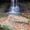
Blue Hen Falls Trail
1.6 mi 2.6 km • 168' Up 51.08 m Up • 168' Down 51.26 m Down
Burning River 100 2022
104.7 mi 168.4 km • 7,971' Up 2429.42 m Up • 7,970' Down 2429.19 m Down
Cuyahog…, OH


0 Comments